Forest and land governance policies are regulated by the Indonesian government through Presidential Instruction No. 6 of 2017 concerning a moratorium on granting new permits for primary natural forests and peatlands, restoration of peatlands in priority areas, evaluation of business license for the utilization of timber forest products in industrial plantation forests, and evaluation of mining business permits in forest areas through the Coordination and Supervision (Korsup) of Corruption Eradication Commission (KPK) together with ministries/agencies and local governments. These policies demonstrate the seriousness of the government towards land and forest governance. Issuance of mining/plantation permits can carry out deforestation and forest degradation if governance is not considered.
One of the efforts to prevent deforestation and forest degradation in Indonesia is to involve the community in participatory forest monitoring. Community participation can describe forest conditions in more detail in their surrounding environment and reports on deforestation can be reported directly by the community. Geographical Information System (GIS) technology can assist the community in monitoring, where all phenomena that occur on the earth’s surface, especially in forest areas, can be identified by GIS which can be used as a guide for the community in the process of monitoring forests in the field.
Based on this, Publish What You Pay (PWYP) Indonesia, which is a coalition of civil society who is concerned about extractive industrial governance in Indonesia together with the Mnukwar Papua Association, held a Focus Group Discussion (FGD) entitled “Monitoring Forest Deforestation by Communities in West Papua Province” on Thursday, August 27, 2020. This discussion aimed to build mutual understanding including collaboration between policymakers from government and civil society in promoting forest and land governance in Indonesia, especially West Papua Province.
Radikal Lukafiardi, Researcher of Publish What You Pay (PWYP) Indonesia, conveyed the results of monitoring based on Global Forest Watch (GFW) that Indonesia had lost 26.8 million hectares of forest or 17% of tree cover in 2000, where the trend tends to increase from 2001 to 2015-2016 and decrease in the following years. The comparison of deforestation data according to the Ministry of Environment and Forestry (KLHK) and GFW showed that the trend of deforestation tends to be the same. Radikal also said that the distribution of forest deforestation that occurred in Indonesia generally occurred on Sumatra and Kalimantan, while Papua still had good forest cover conditions.
GFW data also shows the same condition of forest cover in West Papua Province, where the trend of forest cover loss tended to increase from 2001 to 2015-2016. When further analyzed using the overlapping method on the forest area function map SK no. 783 of 2014 in West Papua and GFW data, it was found that the largest area of forest loss occurred in forest areas for other uses (APL) of 108,880 ha, then followed by production forest 49,290 ha, conversion production forest 44,740 ha, limited production forest 33,440 ha, protected forest 29,250 ha and 12,050 ha of conservation forest. To ascertain whether the forest and land loss is due to extractive industrial activities, an overlay analysis of GFW data with extractive industry concession data is carried out, which is then validated on the Minerba One Data (MODI) portal from the Ministry of Energy and Mineral Resources (KESDM). From the 13 mining concessions (IUP) which have Clear and Clean (CNC) status, five of them have been integrated on the MODI portal, while eight have not yet been integrated. Then, an overlapping analysis was carried out using data on concession areas with the function of forest areas so that it was found that there are oil palm plantation concessions located in conservation forest areas and protected forest areas, while there are mining concessions located in protected forests.
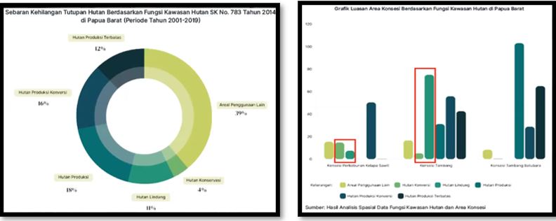 Figure 1. Results of Analysis of Global Forest Monitoring Data in West Papua
Based on the data analysis, it is interesting to know whether the mining concession that carries out the extractive activities already has a Borrowing-to-Use Forest Area Permit (IPPKH) or not because the activity uses forest areas. Overlapping analysis using GFW with concession areas also shows that there have been allegations of deforestation and forest degradation with an area of 4,520 ha in oil palm concessions, 6,400 ha in mining concessions, 6,870 ha in coal mining concessions, and 259,850 ha in non-concession areas
The results of the GFW analysis regarding the condition of forest cover loss in South Manokwari in 2001-2019 showed the extent of forest loss in forest areas was 45% from the total of forest loss in areas for other uses, followed by protected forest areas reaching nearly 25% from the total of forest loss. The latest data on forest loss based on indications of forest cover loss for the period January-June 2020 shows that it tends to occur in areas of other use areas and protected forest areas where it is known that there are 3 mining business permits in South Manokwari with the status, 1 CNC and 2 non-CNC located in the protected forest. However, the results of the GFW data analysis cannot conclude that the deforestation and forest degradation that occur is due to extraction activities, so it requires direct checking in the field to determine the causes of forest cover loss.
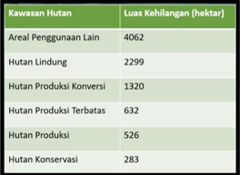 Table 1. Results of Global Forest Watch Data Analysis in South Manokwari
As a partner which is located in the West Papua region, Mnukwar Papua as a local partner of PWYP Indonesia has conducted field checks directly in South Manokwari where Mnukwar Papua’s assistance area is South Manokwari so this is in line with the data on forest loss indication points (Data GLAD Alert) which is suspected to be the point of forest degradation and deforestation. This GLAD Alert data is used as a basis for checking in the field. Starting from the results of the spatial analysis from PWYP Indonesia and South Manokwari, which are Mnukwar’s work areas, the selection of the location for direct checks in the field was carried out in South Manokwari Regency, West Papua Province.
Andi Saragih, the representative of Mnukwar Papua, explained the results of direct field monitoring carried out with the community in South Manokwari Regency. From the six points monitored, it was found that there was indeed forest/land clearing as well as former fields, but the land in question was coordinated with the local community who produced information that these lands were community plantation lands and not mining activities. Andi Saragih also mentioned that the location of the community plantation land is very close to residential areas, which is 100-500 meters away.
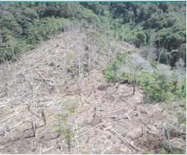 Figure 2. Community Plantation in Protected Forest
Rosa Rantetoding, the representatives from the Department of Energy and Mineral Resources (ESDM) of West Papua Province, clarified that since Law 23 of 2014 was issued and came into effect, the granting of licenses issued by districts/cities becomes the authority of the Province, so in 2018 the districts/cities submit the amount of IUP data that has been processed properly, in exploration and production. IUP was issued by regencies/cities before being handed over to the province indeed IUPs operating in protected forests, but after controlling the permits by the provinces, companies wishing to extend permits to operate in protected forests were no longer granted permits, so the existing IUPs were following current regulation. The Department of Energy and Mineral Resources of West Papua Province in its clarification said that there are indeed 5 IUPs in the South Manokwari Regency, but it has been confirmed that none of them are included in the protected forest area even though the data on Minerba One Map Indonesia shows there is one IUP data located in the protected forest area. Rosa conveyed that she would synchronize the regional data with the central.
Currently, the ESDM office is coordinating with the West Papua Province Industry and Trade Office regarding companies operating in West Papua where it has found that several companies do not have IUPs but have environmental permits that are still carrying out production activities. This situation makes the ESDM office continues to hold technical meetings to solve it. The ESDM office hopes the agencies that participate in data collection can work together to integrate data.
Zulfadli, the West Papua Province Forestry office, responded to IUPs that are inside protected areas that in the regulation of Law 41 of 1999 Article 38 paragraph 1 states that development outside forestry can be carried out in protected forest areas and production forests, which includes mining activities as long as it does not change the landscape. Activities that cannot be carried out at all are activities in a nature reserve/conservation forest area. Related with an IUP issued in South Manokwari Regency which is located in a protected forest, after being checked again by the Forestry office it was found that the company holding the IUP had submitted technical considerations in 2017 due to incomplete administrative requirements, the West Papua Province Forestry office did not provide a recommendation to be forwarded to the One-Stop Integrated Service (PTSP).
Joko Pramono, the General Directorate of Planning, Directorate of Inventory and Monitoring of Forest Resources, Ministry of Environment, said that he has been monitoring forests since 1990 until now. Responding to land cover data, the Ministry of Environment and Forestry agrees with the trend of data submitted by PWYP researchers. Efforts aimed at implementing forest governance, such as deforestation studies and land cover calculations, have also been carried out by the Ministry of Environment and Forestry’s Directorate General of Planning. In a statement, the Ministry of Environment and Forestry reminded that protected forest areas and conservation partners have filters related to IUP. KLHK hopes there will be an information sharing at the regional level so it can be followed up at the national level.
Supin Yohar, Director of Auriga Forests, added that in carrying out good forest and land activities, the history related to forests and land where deforestation and degradation have occurred can be reviewed. One example that can be reviewed is an issue that is often voiced in Papua, such as the handover of the forests and land for oil palm plantations. This is in line with the idea of participatory management where the community can be involved and not be sidelined, as added by Demianus Nayak Soabat, OASE Papua.
Okky-FHPOJA30 East Kalimantan said that NGO groups and communities need to be encouraged to carry out forest monitoring so that it is effective and can be used by the government as a good input for the government so the concerns about deforestation and degradation that occurred in Kalimantan, do not occur in Papua.
Ridwan, The Asia Foundation, proposed the involvement of the parties in monitoring requires good cooperation between CSOs and Regional Apparatus Organizations in the regions so that they do not become polemic but become one information. Then the data can be uploaded on the Global Forest Watch portal where the community can be active in submitting the results of their forest monitoring so that it can become input for the planology at the Ministry of Environment and Forestry to improve the results of the analysis based on the results of the field. Ridwan also added, “In monitoring forests, we must think innovatively regarding the technology that will be built in the community”. (AP/RL)